

Ecuador travel
Tourist attractions in Ecuador
Explore the tourist attractions of Ecuador.

The Milkman Viewpoint
The landscape is made up of a purely agricultural area where corn crops prevail, mainly, and other Andean products typical of the place. We also find eucalyptus forests, pine. The fauna is represented by birds that are typical of the inter-Andean region such as sparrows, blackbirds, huiracchuros, quilicos, quindes, among others. It is a natural viewpoint from where you can see the San Pablo lagoon, the Imbabura volcano, the city of Otavalo, the Fuya Fuya mountain and the Cotacachi volcano. From the traditional point of view, it is a very important place for indigenous customs, since it is a sacred site where purification rituals are carried out among indigenous people of Ecuador and the world. Location It is located 50 minutes on foot from the city of Otavalo in the Eugenio Espejo Parish and is at 2847 meters above sea level. It is a 10-minute walk from Parque Condor. Activities we can do: mystical tourism cultural tourism Photography
51.55 Km.

Saint Paul's Lake
The San Pablo Lake, is a beautiful water hole that is guarded by the majestic Imbabura volcano, it is the largest lake in the province of Imbabura, and offers several paths that lead to natural viewpoints such as El Lechero and Mira Lago. In this lake, the famous swimming crossing takes place every year for the Yamor Festival. The indigenous people go fishing early in the morning in their reed canoes and also take a bath and wash their clothes on the shores of the Lake during the day. In addition to refreshing the gaze when contemplating the landscape, it delights and distracts with the presence of small white sailboats that cross its placid waters, singing with the clean white clothing of the indigenous people who live in the sector and who are a very part of life. imbabureña. How to get? Through the control entrance of Cajas Panamericana Norte, you enter through the Eugenio Espejo sector, a pedestrian bridge is identified, 4 km of paved road.
51.56 Km.

Mariscal Sucre Interpretation Center
Interpretive Center allows you to learn more about the Cotopaxi National Park. Going through the four rooms of the Interpretation Center that was remodeled approximately a year ago by the Support Program for the National System of Protected Areas (SNAP) of the Ministry of the Environment, co-financed by the Federal Republic of Germany through the KFW, is literally entering the ecosystem of the Cotopaxi National Park. The same environment to which the volcano turns, it is remarkable to know the phases of the paramo, according to the guide that guides the visitors there is the sub-paramo at 3400-3900 masl, paramo 3900-4400 masl, the super-paramo that goes from 4400-4900 masl and the icy one of 4900-5897 masl, in addition the colossus is the second highest place in Ecuador. The entire ecosystem is a source of life, not only because it provides fresh water, but also because it provides natural medicine. Also, information is shown on the emergence of springs and several lagoons such as Limpiopungo, Santo Domingo and Cajas. They feed on rain, groundwater and melting ice. These lagoons are a refuge for at least 45 species of birds, there is also data on the 10 highest peaks in Ecuador. The center is dynamic and interpretive, providing data on the 32,000 hectares of the Park, it is open from Monday to Sunday from 09:00 to 15:00 and more than 250,000 people arrive each year, of which the national tourist occupies 70 % and abroad 30%, while 80% attend the Interpretation Center. At the main entrance there is a video surveillance system that transmits both internal and external actions in real time, in order to prevent any type of damage from being done. Likewise, there are several trails such as: del Páramo, Limpiopungo, Kawsay Ñan, among others. Next door there is a "Quinde" handicraft store, Gladys Calvopiña, is in charge of selling, in the place products made in tagua and wood are sold. Everything is produced in Ecuador and by the hands of 20 artisans from the area. "We have a lot of acceptance for quality and price," she said. This has allowed to increase the datafast.
51.86 Km.

Otavalango Museum
Contributes to the conservation and revitalization of the tangible and intangible cultural heritage of the Kichwa Otavalo people, through research, tourism development and cultural education. It shows the customs and traditions of the Otavaleño people, they demonstrate their ancestral clothing and indicate how the fabrics are, in addition they present their dance and music. You can enjoy how they perform the interpretations of the festivities of the Otavaleño people such as: the indigenous marriage, the wake, the music, among other native ceremonies. Location Located 5 minutes from downtown Otavalo. Barrio San Juan, via Antigua a Quiroga #1230, Old San Pedro factory. Entry price Adults $5.00 Children (up to 12 years old) $2.50 Seniors $2.50
52.25 Km.

El Condor Park
We are a non-profit organization dedicated to the protection, rescue, rehabilitation and possible re-introduction to nature of birds of prey, vultures (Andean condor) and owls. Our mission is to create awareness about the importance of environmental problems and their relationship with society, taking the Andean condor, owls, birds of prey and their habitat as the basis for action, as they constitute important indicators and relevant symbols of Andean culture. To fulfill our purposes, we carry out parallel environmental education activities that help us establish connections between these birds and society. As well as self-financing tasks that promote ecotourism Various activities take place in the park, such as: Educational activities such as the protection and care of birds, with special emphasis on the illegal purchase of species and the introduction of non-domestic animals into homes, altering the environment and habitat of the species. Bird of prey training bird of prey rescue Costs and schedules It is open to the public from Wednesday to Sunday from 9:30 a.m. to 5:00 p.m., complementing this with the flight show hours that are at 11:30 a.m. and 3:30 p.m. Ticket prices for adults is USD 4.50, children and people with disabilities at USD 2.00 How to get? From Otavalo, it is located 5 minutes near Otavalo, on the Pucará de Curyloma hill, at 2,800 meters above sea level. You enter through the Panamericana, at the height of the gas station at the entrance of Otavalo, advancing to Piedrahita street in the city of Otavalo; 5 km of road, perfectly signposted, takes us to the very entrance of the park.
52.75 Km.

Peguche Waterfall
The Peguche Waterfall is located in the city of Otavalo, Imbabura Province The Peguche waterfall is located in the Faccha Llacta community, 1.5 km from the Peguche community and 3.3 km from the city of Otavalo. Located at a height of 1821 meters above sea level. and at an average temperature of 12 ° C. This 30 meter high and 6 meter wide waterfall forms on steep slopes. In its surroundings there is shrub vegetation, standing out the elderberry, cholán and mainly blackberries. With a welcoming environment and well defined trails, this place calls us to spend moments of relaxation in the company of friends and family. In addition we can find a second waterfall 6 meters high at the top, which can be easily reached by one of the trails. We can also visit small suitable pools in the lower part, next to the river. The forest surrounding the waterfall has demarcated sites for activities such as camping and picnic. At the Inti Raymi festivals, the Peguche waterfall is the ceremonial center for the purification ritual. In it, dancers from various communities bathe in its waters from 8 at night before starting the dances. How to get to the Peguche Waterfall How to get to the Peguche Waterfall on foot Estimated arrival time: 40 minutes. From the city of Otavalo, we reached the train track and continued north to the community of Peguche and then took the detour to the right, which is located in the UPC Community Police Unit in the area and headed to the Faccha Llacta community. Upon entering the waterfall, they will ask us for registrars and a voluntary financial contribution for the preservation of the area. How to get in your own vehicle to the Peguche waterfall Estimated arrival time: 10 minutes. From the city of Otavalo, we reached Calle Luis de la Torre, next to the railway line and headed north. We take the detour to the right that is in the UPC Community Police Unit and head towards the Faccha Llacta community that has parking areas How to get by public transport to the Peguche waterfall Estimated arrival time: 10 to 20 minutes We can take a taxi in the city of Otavalo. Cost: 3 USD In front of the Otavalo bus terminal, every 30 minutes, we can take a bus from the Imbaburapac cooperative (red bus) that goes to the Peguche waterfall. Ticket value: 35 cents. Activities you can do in the Peguche Waterfall Camping Picnic Photography Hikes Mystical tourism What should we do on our trip to the Peguche waterfall? Warm clothing in winter time Comfortable shoes Mosquito repellent Sunglasses Photographic camera Tips and precautions when visiting the Peguche Waterfall Being at the top of the waterfall, be careful to enter the river to avoid accidents. Collect garbage in bags to deposit them in designated places and places. If an overnight stay is found in the camping area, give notice in the information center for the assignment of the security guard.
53.45 Km.

Cuicocha Lagoon
Cuicocha lagoon, also called “Lagoon of the Gods” or “Tsui Cocha”, is located in the Cotacachi-Cayapas natural reserve, 13 km from Cotacachi canton, province of Imbabura, northern of Ecuador. It originated from the Cotacachi volcano implosion and has 2 islets in its center. The translation of its name would be “Lagoon of Guinea Pigs” because of the presence of these animals in its islets. Its most representative plant is the totora “typha” and its waters are translucent and bluish. The visitors can take boat trips through the islets Yerovi and Teodoro Wolf and the “Dreamy Canal”; they can also practice diving, kayaking or trekking along the path that surrounds it. A legend tells that Cotacachi volcano was the son of the “Rucu Pichincha” (old man) and of the Cotacachi or “Huarmi Huasi” (female hill), and one day the two mountains argued and the father took the son (the “Guagua Pichincha”, a mountain located next to the city of Quito). In the site there was a hole which later became a lagoon because of the mother’s tears. Cuicocha has the form of an enclosed bowl between mountains. By visiting the islets it is possible to observe bubbles in the water, which emerge from the depths in gushes. Supposedly, the lagoon has no bottom. Several people have testified that they saw a mermaid or an ancient city on its vicinity. Here, mysterious phenomena happen, such as the sudden change of the wind’s direction, it is said that this happens when Cuicocha is angry with the visitors and there also are disappearances, screams and weird sounds. The water’s mirror is attractive for its color, but it also frightens, shudders. There is the legend of the gild guinea pig; the first person in seeing it becomes rich, and the second one changes into a duck.
54.05 Km.

Ñanda Mañachi Musical Instruments Workshop
Ñanda Mañachi is a philosophy of life. They are two words that express solidarity in the Andean world. Connected with the "randi randi", the giving and giving or collaboration in the villages of the Ecuadorian highlands. Ñanda Mañachi is translated into Spanish as "lend me the road". It is the name of the gallery-workshop of handicrafts of the Pichamba family, community of Peguche, canton Otavalo, province of Imbabura, in the north of Ecuador. José Luis Pichamba is about to complete 5 decades dedicated to the making of Andean musical instruments. He transmitted his knowledge, or rather inherited it, to his 8 children. The family enterprise has now diversified its offer. His daughters make earrings and necklaces with native designs and dream catchers against nightmares. The Otavalos are an indigenous group from Imbabura. They are a people of musicians, artisans and merchants. Their culture, known internationally, attracts tourists to Peguche. The Pichamba take advantage of this to also offer traditional food and music in their workshop-gallery. The palla, a small rondador typical of Otavalo, takes shape and sound in the skillful hands of José Luis. The workshop is also an exhibition centre for musical instruments from Ecuador, Peru and Bolivia, the Andean area. From its walls hang rondadores, quenas, toyos, charangos, bandolines, guitars. Pichamba as a musician plays various wind, string and percussion instruments. In his business he also sells records of the group Ñanda Mañachi. Ñanda Mañachi is a musical group of internationally famous Otavalan Indians. They are about to celebrate 50 years of career. José Pichamba was a founding member. In 1973, with the participation of 18 indigenous communities of Peguche, Zuleta and Angochagua, 70 indigenous people received training as musicians with Professor Alfonso Cachiguango.
54.42 Km.

Cotopaxi Volcano
The Cotopaxi volcano offers a very beautiful panoramic view, encloses a landscape that covers the vegetation cover on its slopes, mineral features of ancient volcanic eruptions are observed, on its eastern slopes there is a refuge where it allows visitors and visitors a view that encompasses the valley and the Limpiopungo lagoon where there are wild ducks. To go up, you have to ask permission from the authorities of the Cotopaxi National Park. The Cotopaxi volcano is the tallest and most active in the world. The Cotopaxi Ecuador volcano has almost exact snow to a cone is something unique on the planet and is perhaps, like Galapagos, the greatest symbol of our natural wealth, which is known throughout the world. Because it is located in the center of the inter-Andean alley and very close to several cities such as Quito and Latacunga, it is the desire of all tourists to crown El Cotopaxi, which offers a spectacular panoramic view, its landscape allows to know the vegetation on its slopes , you can also visualize the mineral features that have left ancient volcanic eruptions, in its eastern slopes there is a refuge, where tourists can enjoy the scenery to the valley and the Limpiopungo lagoon, include wild ducks in their panorama. A permit granted by the authorities of the Cotopaxi National Park is required for them to ascend. The park is located in a volcanic area, the largest in Ecuador. In the central part is the Cotopaxi, one of the most active and highest volcanoes in the world. The Cotopaxi Ecuador is located in the central sierra region of Ecuador in the Andes Mountains What is the meaning of Cotopaxi? Cotopaxi its name means "neck of the moon", is a place name of our country. You can refer to: Cotopaxi province of Ecuador. Cotopaxi Volcano, in Ecuador. How to get to Cotopaxi Volcano? The Cotopaxi Volcano is located 60 km south of the city of Quito, reached by the Pan-American Highway. There are two well-marked entrances and roads in good condition through which you reach the Cotopaxi moors. From the Pan-American to the first refuge, it is 24 km With half an hour more walking you will reach a hostel built and maintained by the Club de Andinismo of the Colegio San Gabriel, Quito. To enter the Cotopaxi National Park you can use three routes: Pedregal-Tambo, whose access from the north is through the town of Machachi Clirsen-Bowling Area The Chasqui, crossing the center of the camelid program, is the most frequented. For lovers of mountaineering, the Cotopaxi volcano is also a family experience full of color, an extreme adventure to prove dexterity and skill. Biodiversity of the Cotopaxi Volcano A large pine plantation that covers approximately 1750 ha, chuquirahuas, pumamaquis, romerillo, mortiño and capulí, are just some of the species that can be found. In relation to fauna, curiquingues, deer, rabbits, wolves of the moor and the rarely seen Andean condor, can appear at any time. Cotopaxi Volcano Fauna The Andean condor in the Cotopaxi can find this bird that is in danger of extinction, it is an emblematic bird that belongs to the Andean moorland, other specimens such as the spectacled bear, hummingbirds, deer, wolf of moor, field mouse, rabbit wild etc Cotopaxi Volcano Flora It is classified by the type of vegetation as: Humid Forest: It is characterized by that part of the subparagraph where chuquirahua, moss, chilcas, capulí trees, among others, grow. This forest is located at the foot of the Cotopaxi volcano. Páramao pluvial: predominance of páramo straw, lichens and lycopodia. Alpine pluvial tundra: Mosses, lichens and some other species are located in smaller quantities Snow: Where it meets snow the glaciers do not allow the growth of vegetation What should you take Cotopaxi volcano? Warm Wool Cap Warm sweater A windbreaker breaks wind A scarf, warm gloves Trekking shoes Warm stockings Sunglasses, sunscreen Personal water bottle Extra money Camera Snacks Routes to access the Cotopaxi Volcano To reach the highest active volcano in the world, the Cotopaxi, Rumiñahui offers the shortest and most picturesque route called the Inca Trail, via Jatunpungo through the parish of Rumipamba. Average temperature: 3,103 and 3,174 meters above sea level Access time: The estimated travel time is 4 hours Crowning it is not for beginners. Knowing the Cotopaxi volcano is a fascinating experience, both for those who decide to feel the adrenaline and climb it, and for those who just enjoy the beautiful panoramic view that this Andean landscape offers them. Ecotourism lovers can enjoy great natural scenery, the charm of the moors, the magic of its capricious reliefs, the energy of its crystalline rivers, amid a great diversity of flora and fauna, which makes Rumiñahui a compendium of Ecuador's tourist wealth. Source: https://ec.viajandox.com/latacunga/volcan-cotopaxi-A359 https://www.goraymi.com/es-ec/latacunga/volcan-cotopaxi-a69cae589 Images: https://commons.wikimedia.org/wiki/File:Cotopaxi_02.jpg https://commons.wikimedia.org/wiki/File:Volc%C3%A1n_Cotopaxi_-_panoramio_(1).jpg https://commons.wikimedia.org/wiki/File:Nieves_del_Volc%C3%A1n_Cotopaxi_-_panoramio.jpg
56.22 Km.
Cotopaxi National Park
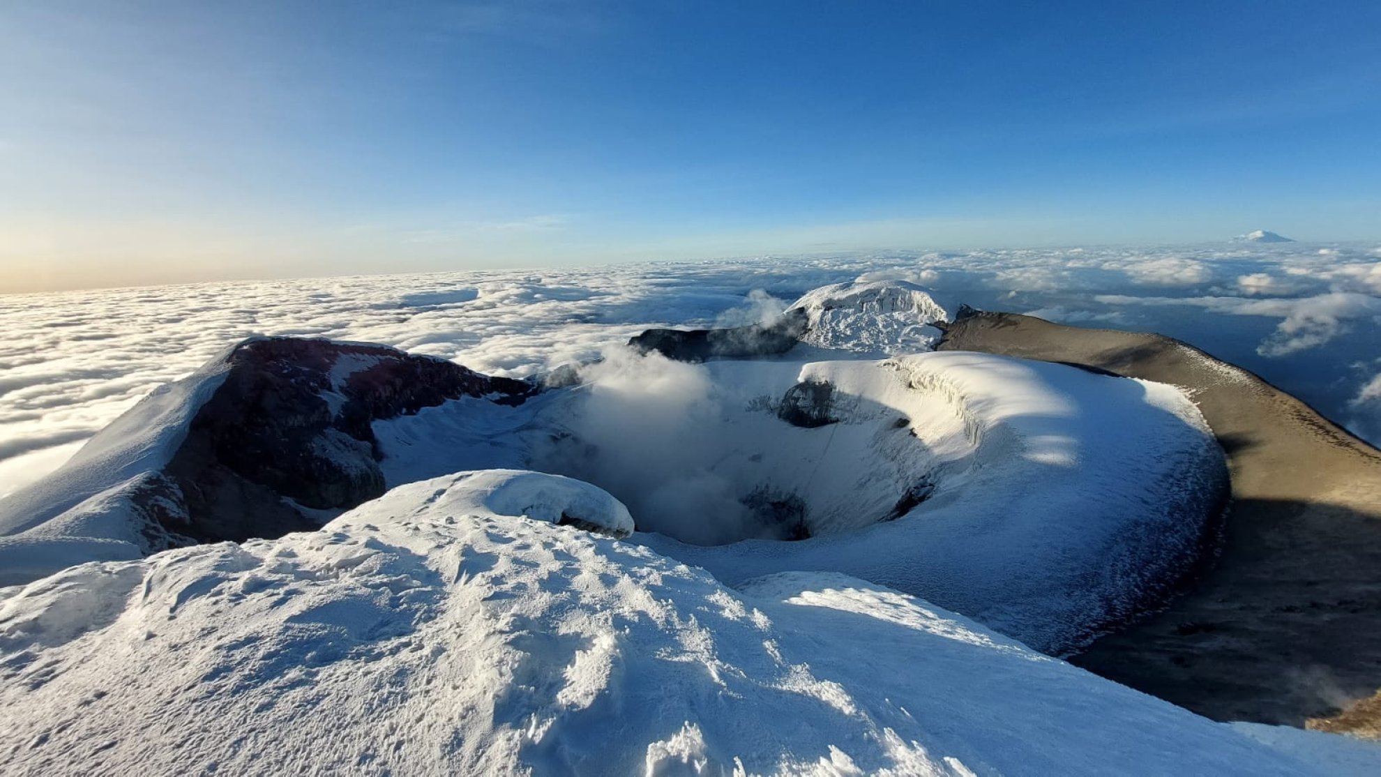
The Cotopaxi volcano, with its majestic snow-capped summit and almost perfect cone shape, stands as an emblem of the Ecuadorian Andes and one of the country's main tourist attractions. This active volcano, located in the heart of Ecuador, is not only a natural jewel that attracts adventurers from all over the world, but also a cultural and historical icon deeply rooted in the identity of Ecuadorians. If you are planning a visit to Ecuador, Cotopaxi should be on your list of must-see places. But what makes it so special? Below, we'll tell you everything you need to know to make your visit unforgettable.
56.37 Km.

Morurco Hill
Cerro Morurco is a rock formation located on the south face of the Cotopaxi Volcano, it is also called the Inca's Head, due to the way its towers or rocky pillars give it; it is generally covered by glaciers; it is the remnant of the old volcanic building that was destroyed in the Pleistocene. El Morurco has a structure of pillars linked by small hills that descend in a north-south direction from the southern moraines of Cotopaxi, it has a height of 4920 m.a.s.l. and is located within the Cotopaxi National Park. During the tour you can also see the Burrohuayco ravine or canyon and the Chuquirahua Waterfall. The climate is particularly cold due to the presence of winds that come from the south, forming glaciers on the mountain. The landscape is made up of parallel packed plateaus and wide ravines, towards the east the topography sinks in the region of the valley at the base of the Quilindaña. To access from Mulaló you have to take the road that leads to the community of Ticatilín, and ascend crossing the sandbanks that are at the foot of it, the weather conditions often do not allow you to reach the top, however, in favorable conditions you can perform rock climbing from the base to almost 300 m upwards (over 4800 m.a.s.l.) for this it is necessary to use special equipment and high mountain guides.
59.72 Km.

Cunuyacu Hot Springs and Waterfall
The natural thermal water pools of Cunuyacu are located at 4125 meters above sea level at the foot of the snowy Iliniza Sur, the Thermal Waters are made up of its two slopes of underground origin, its waters are transparent and of volcanic origin, the waters rest in a kind of pool where they reach a temperature of approximately 22ºC to 25ºC, which is why they are hypothermal waters. They are one of the best preserved treasures in the province of Cotopaxi, like the waterfall of the same name; The small waterfall is shown as a waterfall of about 12 to 15 meters high, the water is at a temperature of approximately 6ºC, these natural attractions are part of the Los Ilinizas Ecological Reserve. Its name comes from two Quechua words yacu = water, cunu = rabbits, it was named in this way due to the large presence of paramo rabbits that inhabit the surroundings of the attraction.
60.70 Km.
We have 413 tourist attractions listed in Ecuador.